 op of Kilimanjaro through the plane window. Most of the passengers on the tiny plane were trekking, and there was a collective sharp intake of breath as we all realised that we were flying at 17000 feet – and the summit is 19000 feet! (An aside: don’t be fooled by the word “International”; the airport is so small, they won’t let you in unless you have a flight ticket, because there’s no space. Fact!)
The entire group of 34 fundraisers from across Ireland and the UK had our pre-trek briefing that evening in our hotel. Superwoman Sarah Perry from Classic Tours was the trek manager; she had taken a group up Kili the week before we arrived, waited for us, was ready to go again (for the fourth time in total), and almost as soon as she got back to the UK would be on her way to lead a three week cycle trek in China. We also met our fabulous doctor, Liz Vallins; this was her second time up Kilimanjaro and she has also travelled to Base Camp Everest in her professional capacity. Sarah introduced us to the man who we would all come to admire over the week – Elias Lyimo, who runs his own trekking business (African Wilderness Adventures) from Arusha. He organised everything – porters, guides, cooks, accommodation, supplies – and without him and his fantastic team, we wouldn't have made it past day one! Can't recommend him highly enough.
Day 1 – Park Gate 1970m to Mandara Huts 2700m
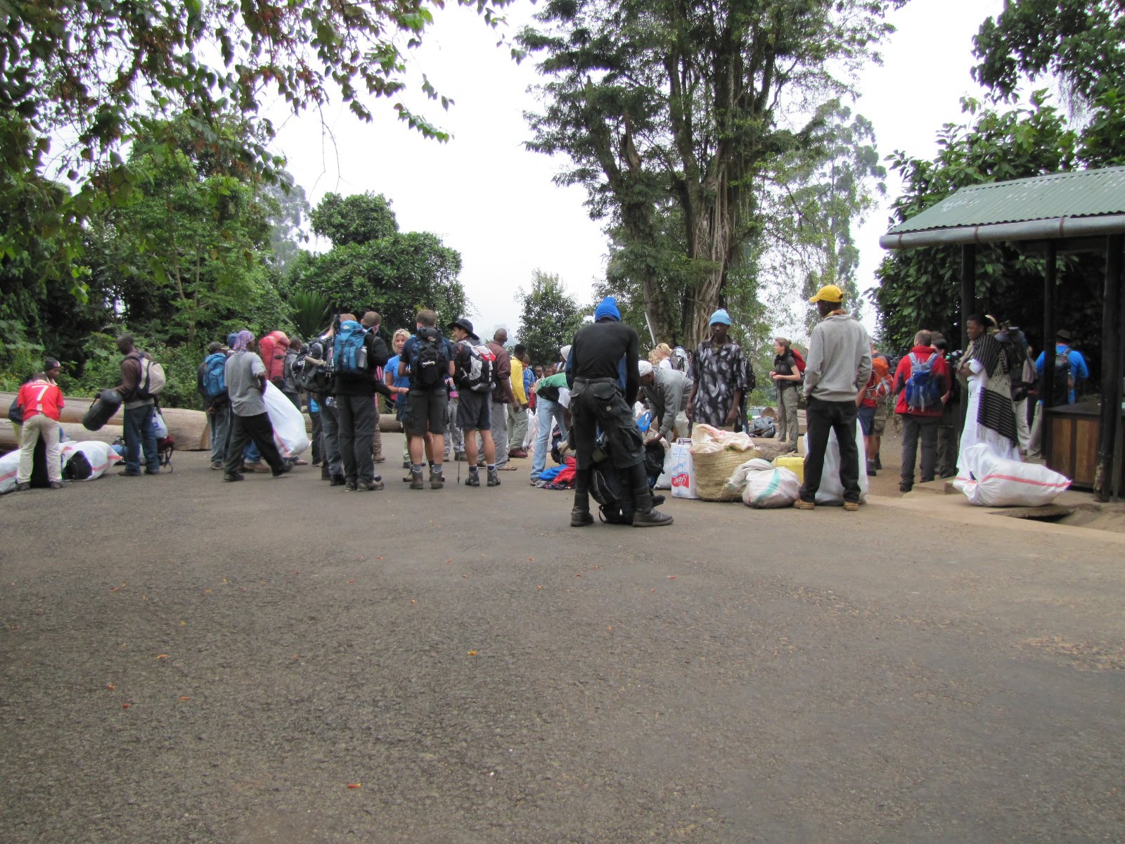
We were driven to Kilimanjaro National Park and the official start of the Marangu Route. Here, we signed in and watched in awe as our “staff” of about 70 porters, guides and cooks loaded themselves up with all the supplies, our duffel bags and their own luggage and happily set off. We had to remain betwe en the front and the back guides, and we had several other guides walking alongside. The front guide set the pace, which was thankfully “pole pole” – slowly slowly! Even if you were the slowest person in the group, there was no pressure to catch up to the front – in fact, this was actively discouraged! Even though we were still fairly low down, we could already feel the effects of exercising at altitude and the rainforest heat was stifling. The vegetation was amazing – huge trees, lush greenery and vivid flowers everywhere.
 en the front and the back guides, and we had several other guides walking alongside. The front guide set the pace, which was thankfully “pole pole” – slowly slowly! Even if you were the slowest person in the group, there was no pressure to catch up to the front – in fact, this was actively discouraged! Even though we were still fairly low down, we could already feel the effects of exercising at altitude and the rainforest heat was stifling. The vegetation was amazing – huge trees, lush greenery and vivid flowers everywhere.
We stopped after about 2 hours for a picnic lunch where we had our first encounter with the “public toilets” – holes in the ground! But these were actually alright compared to the very last camp…let’s just say we quickly got adept at being at one with nature along the way! (And of course...don't forget the fabulous SheWee :-))

Along this section we met several groups descending from the summit. One of them was a girl wearing a wedding veil – she had got married on the summit the day before! It was great to see such happy faces, although several of them warned us that we were not in for an easy time…
We arrived at our first camp, Mandara Huts, at around 4pm. We sorted out our 4 sleeper huts, dumped our backpacks (bliss!) and set off on a short acclimatisation walk to Maundi Crater, from where, on a clear day, the Kenyan border is visible. The daily acclimatisation walk was very important to allow our bodies to adjust slowly to the altitude – the motto was, “walk high, sleep low” (and pole pole, don’t forget!).
When we returned to camp, the best snack ever was waiting for us – hot popcorn!
That evening we gathered around the table for what was our first of several delicious dinners, all prepared as if by magic by the cooks. We always had soup to start – an easy way to warm up and hydrate. Hydration was the number one p riority throughout the trip, especially to combat the symptoms of altitude sickness, and we all carried and drank at least 3 – 4 litres of water a day. However, we were all taking Diamox; this drug increases the rate of oxygen absorption into the body and makes it easier to acclimatise to high altitude, which is great – but it also has the unfortunate side effect of being a diuretic! Getting up in the pitch darkness to find the loos while hoping that the Colobus monkeys you can hear all around you stay where they are is interesting!
 riority throughout the trip, especially to combat the symptoms of altitude sickness, and we all carried and drank at least 3 – 4 litres of water a day. However, we were all taking Diamox; this drug increases the rate of oxygen absorption into the body and makes it easier to acclimatise to high altitude, which is great – but it also has the unfortunate side effect of being a diuretic! Getting up in the pitch darkness to find the loos while hoping that the Colobus monkeys you can hear all around you stay where they are is interesting!
Day 2 – Mandara Huts 2700m – Horombo Huts 3720m
After waking up at 6am to a cacophony of birdcalls, and a great breakfast of porridge, eggs, sausages and toast, we set off bright and early. As we walked, the vegetation changed from rainforest to moorland and we were able to spot our target in the far (far) dista nce. Today’s walk was very long – around 8 hours – and several of the group were starting to experience headaches and nausea. The pace was even slower than the previous day, which helped a lot. We really started to see why the guides are worth their weight in gold – they began forcibly removing backpacks from trekkers who were struggling and carrying them (the backpacks, not the trekkers, although I wouldn’t have been surprised!), they constantly reminded us to keep the pace slow and drink water, and generally distracted us and chivvied us up to our lunch stop. As we got there, the clouds rolled in, so we ate our blessedly hot lunch, soup and all, on the road inside the clouds! The weather was changeable every day, but thankfully we never had rain, and it always cleared up in the mornings and evenings.
 nce. Today’s walk was very long – around 8 hours – and several of the group were starting to experience headaches and nausea. The pace was even slower than the previous day, which helped a lot. We really started to see why the guides are worth their weight in gold – they began forcibly removing backpacks from trekkers who were struggling and carrying them (the backpacks, not the trekkers, although I wouldn’t have been surprised!), they constantly reminded us to keep the pace slow and drink water, and generally distracted us and chivvied us up to our lunch stop. As we got there, the clouds rolled in, so we ate our blessedly hot lunch, soup and all, on the road inside the clouds! The weather was changeable every day, but thankfully we never had rain, and it always cleared up in the mornings and evenings.
On we plodded, feeling much better with some food in our bellies. The ground was extremely dusty due to the dry weather and we were getting dirtier and dirtier!
Finally at around 4pm we reached our second camp, Horombo. We all really liked this camp – the dorms Elias organised were either 4 or 6 sleepers and we still had running water, therefore flushable toilets! There were also two large dining huts which had 20-sleeper dorms above the dining area, as well as some space for tents in the grounds.
Again, we dropped our packs and set off for our  acclimatisation walk. We were all very tired from the long day but, having no choice in the matter, we dragged ourselves onwards and upwards for another hour. When we returned, the weather had cleared and we could see that we were now above the “normal” clouds (not the ones generated by the mountain itself) – surreal!
 acclimatisation walk. We were all very tired from the long day but, having no choice in the matter, we dragged ourselves onwards and upwards for another hour. When we returned, the weather had cleared and we could see that we were now above the “normal” clouds (not the ones generated by the mountain itself) – surreal!
Popcorn was most welcome again, and dinner which was only getting better!
Unfortunately most of us were having trouble sleeping by this stage, which isn’t great for stamina. As a bonus for the insomniacs, we had no moon all week which made the night sky absolutely breathtaking – the Milky Way, Jupiter and more stars than many of us had ever seen were clearly visible. If it hadn't been so cold at night many of us would have stayed out there.
Day 3 – Acclimatisation Day – Horombo Huts 3720m – Zebra Rock 4020m
A relaxed day - we were able to lie in until 7am! After enjoying our hearty breakfast, we set off around 9am towards Zebra Rock. As the name implies, this large section of the rock face is striped black and white from carbon and sodium oxide deposits. Here, we had our group photos  taken in our charity t-shirts.
 taken in our charity t-shirts.
After a quick snack break, we set off over the ridge. As we reached the top, many of the group were gazing into the distance in silence…we looked over and there, stretching infinitely ahead, was the long, dusty road to Kibo…it looked endless, and the summit was still as far as it had ever been!
Trying to put it to the backs of our minds, we walked back down to Horombo. Walking downhill was an absolute pleasure – we could immediately feel the difference although we still couldn’t walk at our normal pace. Many people’s symptoms improved a lot going even a few hundred metres downhill, although for some they didn’t improve at all. Paracetamol, Ibuprofen and nausea tablet s were being handed around like sweets.
 s were being handed around like sweets.
Today’s lunch was fit for a king! The chefs pulled out all the stops and we feasted on pasta, mince, salad, pancakes and fruit. We almost didn’t have space for dinner that night. Almost.
We spent the rest of the afternoon relaxing and repacking our bags. One of the girls bit the bullet and washed her hair in the icy water – the rest of us weren’t so brave and embraced the filth! Our baby wipe bath routine had by this stage become very efficient for the crucial bits – the rest would just have to wait.
While in the camp, a lot of us forgot we were at altitude and tried to walk around at a normal pace. We all discovered the error of our ways after just a few steps – we became so breathless we had to stop and rest before carrying on as we were meant to, pole pole! It was very odd having to saunter to the loo and to dinner instead of just getting places quickly, as we usually do. A lesson in taking it easy and enjoying the scenery along the way!
Day 4 – Horombo Huts 3720m – Kibo Huts 4750m
Many of us rose early to catch the sunrise over Horombo – it was beautiful, and the sun lit up the glacier on the summit, bathing it in a peachy red glow.


Today was another extremely long and sometimes difficult day; at least much of it was fairly flattish. We still went up but over a much longer period of time. It took us a good 8 hours along what felt like the surface of the moon towards the end – dry, dusty, not a plant or even an insect to be found, only the ravens which we were sure had followed us all the way from the gates – very Edgar Allan Poe. On the plus side, the views were increasingly spectacular. Mawenzi, the third highest peak in Africa, loomed jagged and menacing to our right as we trudged along towards Kili in the distance.
This was also when we truly left our inhibitions to one side as decent cover was increasingly rare – much of the time we relied on the politeness of our trek-mates not to look if nature called!
We stopped for a picnic lunch at a rocky section where some life was to be found – more ravens (“nevermore…”), tiny finch-like birds and four-striped mice, who feasted on our leftovers. Litter is unfortunately a big problem along the route – there is much evidence of people before you, which is a shame, however the food does provide for th e only living creatures hardy enough to survive those lunar conditions.
 e only living creatures hardy enough to survive those lunar conditions.
Towards the end of the trail, the clouds generated by the mountain itself rolled in again and it truly felt as if we were on a different planet!
Finally, we reached our destination. Kibo was the most basic of our accommodation – we had passed the no water mark several kilometres back and the dormitories were 12 sleepers, which meant that they were more crowded, but also more difficult to keep warm. We were very glad not to be in the tents dotted around the camp as the temperature during the night dropped well below zero degrees. On a positive note, this did have the rather fortunate effect of freezing the waste in the chemical toilets which made them less unpleasant to use in the morning!
We were now within sight of our goal. Having dropped our bags we set off up the slope for our acclimatisation walk. This was the slope up which we would be climbing the following night, and as we walked we began to get nervous, as the terrain was definitely not easy – the slope all loose, slippery scree: you place one foot down, and immediately you slide backwards a little; and on and on!
Back at camp, we eagerly tucked into our hot dinner and headed straight for our sleeping bags. Unfortunately, sleep was elusive once more for many!
Day 5 - 6 – Acclimatisation Day and Summit Night / Day 6 Kibo – Horombo
Day five dawned, and we had a “lie in” until 7am. This morning we would be going on our last acclimatisation walk, a third of the way up the scree slope. Symptoms of altitude sickness were well and truly manifesting and many of the group were taking painkillers and anti-nausea medication.
We struggled our way up the slope until we were almost level with Mawenzi peak, and down again to Kibo. 

After lunch, Sarah gave us our pre-summit briefing. For the rest of the afternoon, we were to rest and prepare for an 11pm start up the scree slope. We had an early dinner at 5pm, then back to our sleeping bags. There wasn’t much rest to be had though, not only due to the altitude, but also because we were very nervous. We knew it would be difficult, but how difficult? Would we make it to the top? What if we couldn’t go on?
10pm and the wake up call came. We scrambled out of our lovely warm sleeping bags and pulled on our layers: 1 pair of thin socks, 1 pair of heavy woollen socks, boots; thermal leggings, trekking trousers and waterproof trousers; 2 base layer tops, 2 fleeces, one down jacket and one windproof jacket; one beanie; one balaclava; one thin pair of gloves and one pair of ski gloves. The temperature was well under 0C and it was getting colder. Luckily, there was no wind. We also filled up our water bottles with 4 ½ litres each of hot water – it had to be hot, or it would freeze before we had even reached the halfway mark.
After a very quick cup of tea and a biscuit for those who could eat, we were off.
The mood was quiet and apprehensive as we began the long and very, very slow ascent of the scree slope, in single file, watching the feet of the person in front of us. Ahead, all that could be seen was a line of head torches bobbing through the night in a zigzag pattern: the slope is too steep and slippery to climb in a straight line. The scree is loose and each step sinks and slides backwards. You can’t see where you are going, so you have no idea how far the summit is. All we could see was the never ending line of lights ahead, the line of lights behind, and the feet in front. Hours felt like minutes, minutes like decades, and eventually we stopped thinking altogether. The guides really were really worth their weight in gold this night, helping us, taking backpacks from those who were exhausted, and reminding us to drink water and eat our (frozen!) snacks on our brief breaks.
The mood was quiet and apprehensive as we began the long and very, very slow ascent of the scree slope, in single file, watching the feet of the person in front of us. Ahead, all that could be seen was a line of head torches bobbing through the night in a zigzag pattern: the slope is too steep and slippery to climb in a straight line. The scree is loose and each step sinks and slides backwards. You can’t see where you are going, so you have no idea how far the summit is. All we could see was the never ending line of lights ahead, the line of lights behind, and the feet in front. Hours felt like minutes, minutes like decades, and eventually we stopped thinking altogether. The guides really were really worth their weight in gold this night, helping us, taking backpacks from those who were exhausted, and reminding us to drink water and eat our (frozen!) snacks on our brief breaks.
Unfortunately, it was this slope that got the better of four in our group, two of whom had to be sent down by the doctor due to worsening altitude sickness. The only treatment for this is descent, and if symptoms do not improve after descending a few hundred metres, the affected person must continue to descend or risk serious complications such as pulmonary or cerebral oedema. We had already seen four people being stretchered down the mountain in four days, so we were aware that this was a possibility, but of course the disappointment was no less distressing for the people who had to go back.
The rest of us trudged on for what felt like aeons, but turned out to be around 5 – 6 hours. Finally, painfully, we reached the end of the scree slope…to find that we had to clamber over some rocks for another half an hour or so. Devastating!

Eventually we staggered over the last few rocks to Gilman’s Point. We had arrived at what once was the official peak of Kilimanjaro, at 5685m / 18651ft. The sun had risen and the view was breathtaking and dizzying, the curve of the earth and the line between our atmosphere and space clearly visible – if we had been able to appreciate it at the time I’m sure it would have been even better! Thankfully after a little rest we felt better and were more able to take in our surroundings.
Gilman's is where I stopped. The exhaustion was just too much for me - I'd never experienced that level of physical exertion and my body and mind were just finished. But I got my certificate :-)

My husband pressed on. From here, it was yet another 4 hour round trip to Uhuru, the highest point at 5895m / 19340ft. Remember this is 2000 feet higher than the maximum altitude at which the plane from Nairobi was flying! Although the temperature was around -15C, it's so much closer to the sun that he still needed to apply Factor 50 sunscreen or risk severe sunburn. The glaciers were spectacular and, although much smaller than in the past, still imposing and impressive. It felt like the whole of Africa was spread out before him.


Due to the altitude and the cold, he couldn’t stay for long, so after a very inadequate rest (and photos!) it was back to Gilman’s, then down the scree slope to Kibo…for the brave and still energetic, there is a shortcut – you can run down the slope placing all the weight on your heel and sliding down, similar to skiing. This saves a lot of time, but be careful to avoid the big rocks that you hurtle towards at speed! Also, this is not recommended to those with any sort of knee trouble!
We were all like zombies when we arrived back at Kibo. We could barely speak and had the glassy stare of people who had just experienced major trauma. It was now around 11am and we had last eaten at 5pm the evening before; many of us hadn’t slept properly in days; we had spent the entire night hiking and we hadn’t been able to drink all our water, so it was no wonder we felt so bad.
We had only an hour’s rest before we had to drag ourselves out of bed again for a quick light lunch, and then back on the dusty road down to Horombo.
Some of us didn’t even make it to dinner that night – that was the first time in six days not one person complained of insomnia. The entire camp was dead to the world for 10 hours!
Day 7 – Horombo – Park Gate
The next day, feeling much more human and excited about the previous day’s achievement, we continued down the mountain. Finally we were able to walk at a normal pace – the lower we got, the better we felt!
We stopped at Mandara for lunch and discovered the best surprise – delicious cans of coke had been brought up for us by one porter in only half an hour from the main gate, a trip that would have taken us at least 3 hours! 

After lunch, we rapidly descended back through the rainforest, and there was the main gate and the end of our epic journey. Another surprise was waiting for us – bottles of sparkling wine!
That evening at our hotel, we relished our first shower in a week and our Kilimanjaro beers were the most delectable drinks we had ever tasted.
The following day, we were back at the airport and flying home, wondering, “Did that really happen?”
And of course, planning our next trip.


 As we descended the weather improved until it was gloriously sunny. We stopped for our picnic lunch and thank goodness for flasks with hot tea, is all I can say!