We had decided, with guidance from Kieran at the Great Outdoors (our Guru re all things Kilimanjaro) to hike Tonelagee, leaving one car at Laragh and starting from further up the R756, so rather than going straight up and down like we had been we could experience different terrain and views all the way. We parked the second car at Wicklow Gap and (after my husband revived himself with a chocolate bar - can't go more than a few hours without sustenance) began our climb!
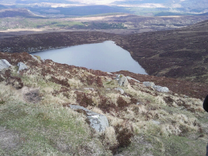
The first challenge was to find a path. We could see a few people up ahead of us but no path...we ploughed on regardless through the scrub, certain we would come across it sometime before the top...and kept going, kept going, kept going...no path! It was pretty cool feeling like you were the first ones there! HOWEVER...a word to the weary - if you do it in this way, the route up is practically vertical!!! We were exhausted just getting up to the summit which was only a few hours, if that. We were never so happy to get to the actual summit (those false summits are going to KILL me) and take in the stunning views over the Reservoir and Lough Ouler.
We have invested in an Ordinance Survey map of the area and this proved invaluable when trying to plot our descent (still no path!). The contour lines were our saviours because had we chosen the wrong path, things could have gone quite pear-shaped (like me! HA!) as it was extremely steep in places, with lots of rocks waiting to send you to your doom and hidden holes in which to twist your ankle. (Although a helicopter rescue did seem like a good idea at the time.)
Once we had navigated the still interesting descent, we could take it a bit easier. The return journey was mostly descent and flat and went through fantastic grasslands and wooded areas. We passed a herd of deer and could see evidence of lots of wildlife. The best thing about this climb was that we passed exactly three people - it was absolutely the quietest area we've been in so far. Added bonus - no small children or the elderly out to make us feel completely inadequate!
This hike was also my opportunity to use my new toy (guys look away now) - a SheWee! This amazing invention is a silicone funnel ladies ("ladies") can use to pee while standing up. I know most men won't immediately understand the significance of this so try this out (maybe not so your neighbours can see): with your hiking gear on, including backpack because you can't put it down in case it gets wet, and hunched over so a straggly bush at least attempts to cover your shame, pull your trousers down just enough to expose your bottom but not so far that other people can see what's what. Do the same with your underwear. Squat precariously on the uneven ground (if it's sheltered, it's uneven; if it's even, it's in the open - law of nature), while keeping backpack, trousers and underwear clear of the mucky ground and also away from the business end of things. While balancing thus like a circus perfomer, attempt to relieve yourself downhill but away from your feet, making sure you do not topple backwards, sideways, or forwards, with all the muscles in your thighs clenched. Once this has been achieved - and don't worry, it will never feel like actual relief because you can't get it all out in this abominable way - use a scrap of toilet paper to dry out, again keeping all clothes etc away from the ground. Find somewhere to put toilet paper. Pull up underwear and trousers while in this position because if you stand up everyone can see you. Try not to fall over while doing this. Wobble back to your group where the men will have jovially watered the countryside and ask "What takes you girls sooooo long???"
Hence - the SheWee. You just need to unzip, push the underwear aside, position the funnel and presto, peeing standing up. Best. Invention. EVER. Seriously, any ladies who hike often - check it out. Do it now!
Right, I've finished proselytising now.
We finally reached a dirt road (civilisation!) which would lead us back to Laragh, following the Glenmacnass River.
After another few hours the stile that marked the end of our hike appeared There was a sign on it facing the other way, which we assumed was a welcome or perhaps directions. Full of the joys of spring we skipped over it and turned around. It said, "Warning! Hunting season. Stick to the marked trail."
Remember the deer we saw...?
Summary: max altitude 817 metres, total time around 6 hours.
No comments:
Post a Comment